


Mapit Spatial - GIS Data Collector & Measurements
Description of Mapit Spatial - GIS Data Collector & Measurements
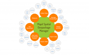
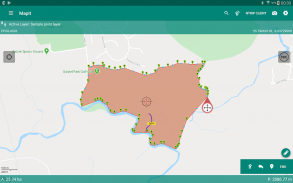
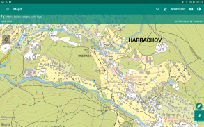
This application is our flag product and more sophisticated version of the older apps called MapPad and Mapit GIS with some new ideas implemented and completely redesigned data management approach and is providing multi-purpose mapping solution allowing location capture and determines distance and area for the shapes drawn on the map or captured using real-time GPS tracking.
Use Mapit Spatial to record spatial data, calculate areas, perimeters and distances. Organise your workflow utilising Geopackages and data layers.
Save, export or share your measurements and survey results immediately as they are completed.
The app is designed to be simple and light and driven by new OGC file format for storing spatial data.
Detailed user guide in form of pdf document is available on our website - https://spatial.mapitgis.com/user-guide
Directly from the app you can access existing multiple Geopackages data sources and their content presented as tiled or feature layers.
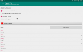
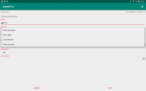
You can also create new Geopackage databases and feature layers and link their fields with the attribute set fields, so the data can be then collected using forms containing drop-down lists, multi-select list, barcode scanner etc. Please see our website for more details.
Collected information can be accessed immediately by simply copying the whole Geopackage file to the PC and linking to it from GIS Software like qGIS.
The application is supporting multiple coordinates projections and you can specify your default coordinate system by providing the EPSG code in the settings - PRJ4 library is used to convert coordinates.
The application is capable to link with high precision GNSS systems - so you can get down to centimetre accuracy if required and take advantage of the RTK solutions provided by the leading GNSS manufacturers.
With Mapit Spatial you can capture, manage and share your data easily. Supported export and import formats: SHP File, GeoJSON, ArcJSON, KML, GPX, CSV and AutoCAD DXF.
Custom WMS, WMTS, WFS, XYZ or ArcGIS Server Tiled services can be added to the software in form of overlays.
Three methods of measurement are supported in form of GPS location, Map cursor location and Distance & Bearing method.
Mapit Spatial can be used in number of applications including:
- environmental surveys,
- woodland surveys,
- forestry planning and woodland management surveys,
- agriculture and soils' types surveys,
- road constructions,
- land surveying,
- solar panels applications,
- roofing and fencing,
- tree surveys,
- GPS and GNSS surveying,
- site surveying and soil samples gathering
- snow removal
The GIS Software and spatial data gathering and processing is getting more and more important these days all over the world and the ability having quick, fast and reliable workflow is becoming very important. Mapit Pro has become a day-to-day tool for thousands of people across the world and we are hoping that Mapit Spatial is going to improve and make your workflow more efficient and cost-effective.
We would like to address our application to everyone who is working with
geographic data and is responsible for location related tasks. There is
number of science and business-related areas relying or depending on the
accurate information coming from Geographic Information Systems and we do
hope Mapit Spatial is going to become your day-to-day tool when you are
making things right out there in the field.
Specifically, the app is dedicated to people working in agriculture,
forestry, housing development or land survey industry, but also to customers
responsible for design work in power industry, water supply and sewage
systems. We have successful customers also from gas industry, telecommunication and road engineering.
Mapit Spatial can be also adopted for any kind of spatial asset management tasks, fishery and hunting, habitat and soil mapping or to whatever needs you can think off, but of
which the authors of the application have never thought.
Mapit Spatial - GIS Data Collector & Measurements - Version 2.8.1.0Core
(21-07-2021)Mapit Spatial - GIS Data Collector & Measurements - APK Information
APK Version: 2.8.1.0CorePackage: com.mapitgis.spatialLatest Version of Mapit Spatial - GIS Data Collector & Measurements
Other versions


Apps in the same category

You may also like...


